
1960 Geography Field Trip
During the 1950s, a number of Grammar School subjects introduced field trips. This photo was taken during July 1960 when R.G. Haywood and Ron Illingworth escorted a party of 20 pupils to the Lake District.
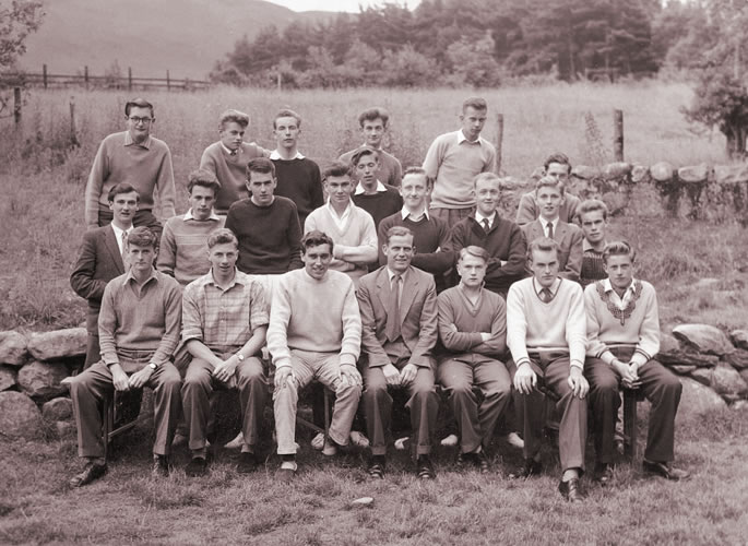
Back Row: M. Elson, G. Garner, Bennett, R. Bluff, Atkin
Middle Row: M01, M. Haynes, Thomas, Peter Jordan, Payne, Smith, M07, David Brunning, M09 (obscured), Stirton
Front Row: P. Hill, P. Gardener, R.G. Haywood, Ron Illingworth, J. Diggens, Taylor, M. Whitewood
The party of boys left Burton on Friday, 15th July for a week’s geographical work in the Lake District under the supervision of Mr. Illingworth and Mr. Haywood. The journey used Stevenson’s Coach and the route taken took them through Preston and Lancaster (being of course, before the availability of the M6 motorway) and through the Lakes to their final destination of Newlands, three miles south-west of Keswick, on the western shore of Lake Derwentwater. Finally arriving at Newlands Hostel around five o’clock, the first thing to do was to unpack everything and have dinner.
Saturday, the first full day, was taken up with a ridge-walk along Causey Pike to the village of Buttermere. The Cumbrian coast and Southern Uplands of Scotland were just visible on parts of the walk. Due to the dangerously steep descent and the time factor, a visit to the actual Buttermere village was abandoned, favouring the less steep descent of Whiteless Pass to the Valley of Soul Beck and following the ‘Becks’ back to Newlands.
Sunday saw the party in the lovely countryside of Watendleth and Borrowdale. The Loclere Falls was the starting point after a boat trip across Lake Derwentwater. The first stop was Watendleth Valley where the local shop did good trade in chocolate, postcards and stamps. From here, the walk took them through Borrowdale to the small village of Grange.
On Monday, the party was taken on an ‘Urban Morphology’. The two towns of Keswick and Cockermouth had been chosen and the party split into two groups with a master going to each town to supervise their studies. Back at the Hostel in the evening, the various findings were recorded. The next day, reports on the work was presented by Mr. Haywood.
 Tuesday saw the first bad weather. The planned route for the day was along the Cat Bells Ridge to Dale Head Tarn but half way along the ridge, thick dark clouds came down with the start of some rain so the party returned to the Hostel, finding the best possible shelter on the way arriving back some time before dinner time.
Farm studies were the task for Wednesday. The party was this time divided into three groups with a nominated leader in each. The three areas surveyed were Borrowdale Valley, Bassenthwaite Lake, east-side and Bassenthwaite Lake, west-side. During the course of the day, Mr. Illingworth and Mr. Haywood visited all three groups and after dinner back at the Hostel, the group leaders gave their report.
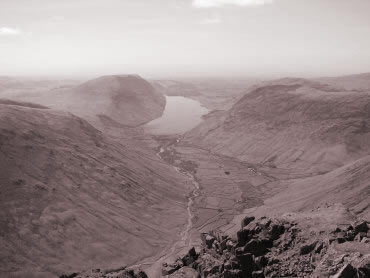
The last full day, Thursday, was spent climbing the Great Gable. The party was taken by bus to Thornywaite. From here, they walked through the village of Seathwaite and, in what became fairly heavy rain, they proceeded to the summit (2,949 ft.). Despite the light veil of cloud, the view was thought well worth the effort ( pictured ).
Friday morning was spent packing before the Stevenson’s Coach arrived for the return journey.
